Augmented Reality Satellite Tracking
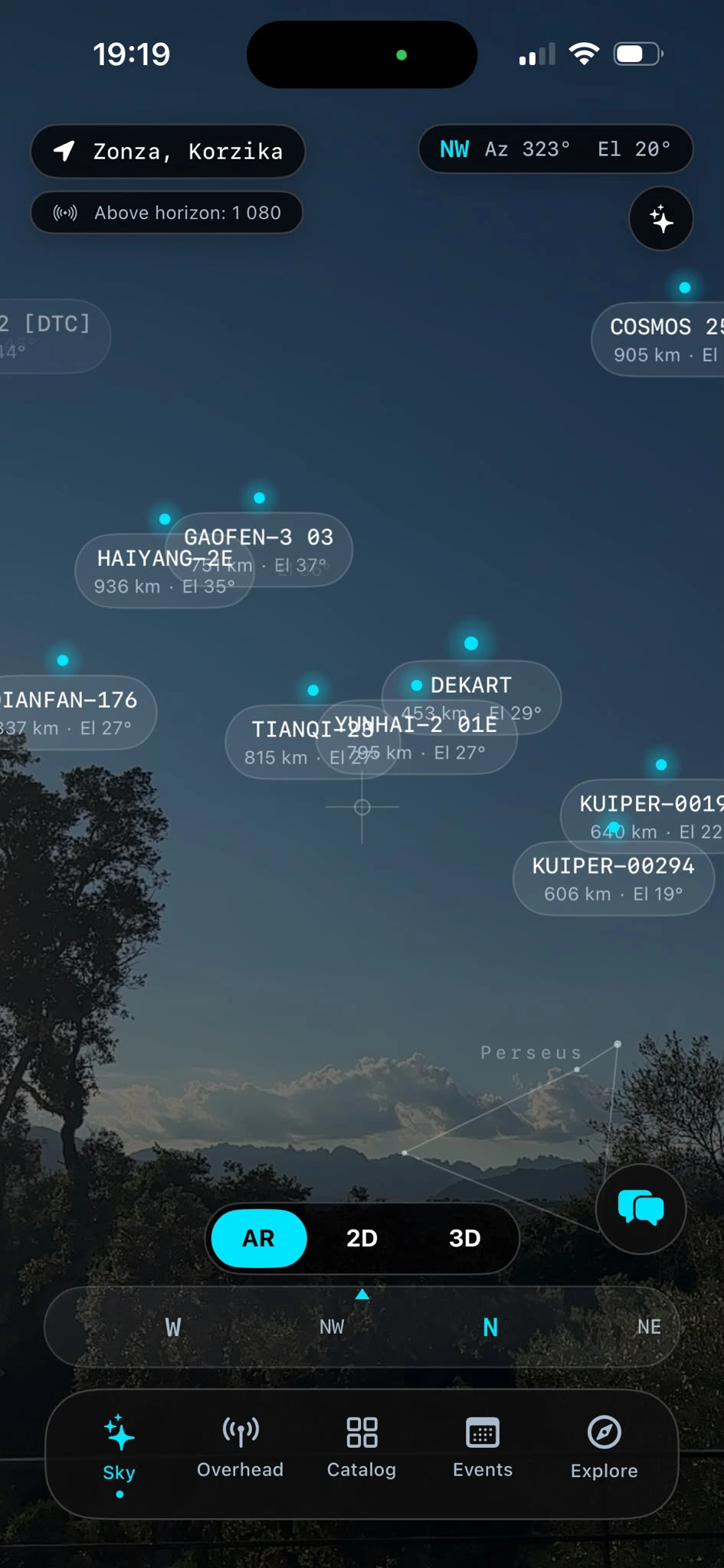
A new augmented reality application, Orbit, has been launched on Hacker News, offering users the ability to visualize and track over 15,000 satellites in Earth's orbit. The app, presented in a "Show HN" post, leverages augmented reality to overlay satellite positions onto the user's real-world environment through their mobile device. This allows for an intuitive and engaging way to understand the scale and density of objects currently orbiting our planet.
The core functionality of Orbit is its ability to display a vast catalog of space objects, including active satellites, defunct satellites, rocket bodies, and other debris. By utilizing real-time orbital data, the application accurately projects the current and predicted paths of these objects against the backdrop of the user's surroundings. This provides a unique perspective, transforming abstract orbital mechanics into a tangible visual experience. Users can pan, zoom, and rotate the AR view to explore the orbital paths from different angles, gaining a deeper appreciation for the complex choreography happening above us.
The sheer number of objects – over 15,000 – highlights the increasing congestion in Earth's orbit. Orbit makes this information accessible and understandable, moving beyond static charts and complex ephemeris data. The use of AR is particularly effective here; think of it less like a traditional astronomy app and more like holding a live, 3D model of Earth's orbital neighborhood in your hands. You can point your phone at the sky and see exactly where the International Space Station is, or trace the trajectory of a recently launched payload.
Technical Underpinnings and Data Sources
While the technical details shared in the Hacker News thread are limited, the project clearly relies on accurate orbital data. Satellite tracking applications typically source their information from publicly available Two-Line Element (TLE) sets, which are published by organizations like the Joint Space Operations Center (J-Space) of the U.S. Strategic Command. These TLEs are sets of orbital elements that describe the orbit of an Earth-orbiting object at a specific point in time. Algorithms then propagate these elements forward to predict future positions.
Developing an AR application that can smoothly render and track thousands of objects in real-time presents significant computational challenges. The application must efficiently process orbital data, perform complex calculations for AR projection, and render the 3D models of satellites without lag. The success of Orbit suggests that the developer has found an effective way to manage this complexity, likely through optimized rendering techniques and efficient data handling. The responsiveness of the AR overlay is crucial for a compelling user experience, and the "Show HN" nature of the post implies a functional, user-facing product.
The ability to track such a large number of objects also means the app likely filters and categorizes them. Users might expect to see options to highlight specific types of satellites (e.g., active, inactive, scientific, military), or to track particular constellations like Starlink or OneWeb. The prompt mentions 15k+ objects, which goes beyond just active satellites and includes a significant amount of space debris, an increasingly important area of study and concern for space operations.
User Experience and Potential Applications
The primary appeal of Orbit lies in its user-friendly interface and the novelty of AR-based visualization. For space enthusiasts, amateur astronomers, and students, it offers an unprecedented way to engage with space. Imagine a classroom where students can use Orbit to see satellites pass overhead during a lesson on orbital mechanics or space exploration. For developers and engineers working in the aerospace industry, it could serve as a quick, visual reference tool to understand the orbital environment around specific assets.
The AR perspective is more than just a gimmick; it provides an intuitive spatial understanding that is difficult to achieve with 2D maps or data tables. Users can easily grasp concepts like orbital inclination, altitude, and relative speed by observing the satellites in motion within their own environment. This direct visualization can foster a deeper understanding and appreciation for the engineering and physics involved in spaceflight.
What nobody has addressed yet is the potential for this AR visualization to inform public perception and policy regarding space sustainability. Seeing the sheer density of objects in orbit, especially the debris, could be a powerful advocacy tool. It makes the invisible problem of space congestion visible and personal.
Community Reception and Future Directions
The Hacker News community, known for its technical insight and critical feedback, will likely probe the app's data accuracy, performance, and potential features. "Show HN" posts often lead to lively discussions about the technology stack, development challenges, and future roadmaps. It will be interesting to see if the developer plans to integrate more advanced features, such as collision avoidance warnings, detailed satellite information (payload, mission), or even integration with ground station tracking data.
The current offering focuses on visualization, but the underlying data and AR framework could be extended. Potential future developments might include educational modules, real-time alerts for visible satellite passes, or even simulations of orbital maneuvers. The success of Orbit could pave the way for more sophisticated AR applications in the aerospace domain, bridging the gap between the digital and physical worlds of space exploration and management.