The Geospatial Data Bottleneck in Data Lakes
For years, storing and querying geospatial data within data lake architectures has been a significant hurdle. Traditional approaches treated spatial data as opaque blobs or simple coordinate pairs, rendering it invisible to the query engine's optimization capabilities. This meant that even with advanced table formats like Apache Iceberg, which excel at optimizing queries on structured data like timestamps or integers, spatial queries remained inefficient. A common scenario involved a logistics team with millions of delivery stops, each with latitude and longitude. When an analyst needed to find stops within a specific metropolitan polygon, the query engine had to scan every single data file in the table. This resulted in reading tens of millions of rows to retrieve a mere few hundred thousand, a process that consumed excessive resources and time.
The core issue was that neither the table format (Iceberg) nor the file format (like Parquet) understood the inherent spatial nature of the data. Optimizations such as min/max pruning or partition transforms, which are standard for temporal or numerical data, simply couldn't be applied. This effectively relegated spatial data to a second-class citizen within the data lake, limiting its utility for critical analytical tasks.
Iceberg 3.0: Native Geometry and Geography Types Emerge
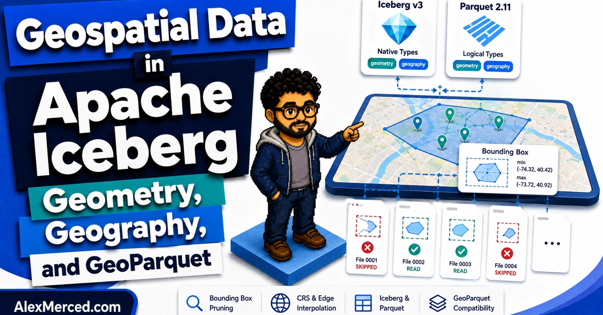
Apache Iceberg version 3 marks a pivotal shift with the introduction of two native primitive types: geometry and geography. This is not merely an addition of new data types; it's a fundamental change in how Iceberg understands and manages spatial information. By natively supporting these types, Iceberg can now leverage their inherent properties for optimization. This means that standard Iceberg features, previously unavailable to spatial data, can now be applied.
The geometry type is designed for planar (flat-earth) coordinate systems, suitable for local analyses or data where projection is handled externally. The geography type, on the other hand, is specifically for spherical coordinate systems (like WGS84), which are essential for global-scale analyses where the curvature of the Earth must be accounted for. Having these distinct types allows for more precise and contextually appropriate data handling and querying.
This native support enables Iceberg's metadata to store information about the spatial extent of data within each file. For instance, Iceberg can now record bounding box information for the geometries contained within a data file. This metadata is the key to unlocking significant query performance improvements. When a query specifies a spatial filter (like the metro area polygon), Iceberg can consult this metadata and perform intelligent pruning, discarding entire data files that do not intersect with the query's spatial bounds. This dramatically reduces the amount of data that needs to be read from storage, leading to faster query execution and lower computational costs.
GeoParquet: Standardizing Spatial Data at the File Level
Complementing Iceberg's native types, Apache Parquet version 2.11 has introduced corresponding logical types for geometry and geography. This is crucial because Iceberg often relies on underlying file formats like Parquet to store the actual data. When data is written in GeoParquet format, which embeds these new logical types, Iceberg can fully leverage this information.
GeoParquet is an open standard that builds upon the Parquet format to add explicit support for geospatial data. It defines how to store various geometry types (points, lines, polygons, etc.) and their associated coordinate reference systems (CRS) within Parquet files. With the integration of native GeoParquet logical types, Iceberg can now inspect the contents of a Parquet file and understand its spatial characteristics without needing to read the entire file. This allows for file-level pruning based on spatial predicates, a capability that was largely absent before.
The synergy between Iceberg's table format capabilities and GeoParquet's file format standards creates a powerful combination. Iceberg provides the metadata management and table-level optimizations, while GeoParquet ensures that spatial data is stored efficiently and semantically within the data files. This dual approach means that spatial queries can be optimized at multiple levels: table metadata (pruning entire files based on broad spatial extents) and file content (pruning within files if the underlying format supports it, which GeoParquet now does explicitly via logical types).
Performance Implications and Future Directions
The implications of these developments are profound. For organizations dealing with large-scale geospatial datasets – such as those in logistics, urban planning, environmental monitoring, or telecommunications – this represents a significant leap in analytical capability. The ability to perform spatial operations directly on the data lake with high performance means that complex analyses, which previously required specialized data warehouses or ETL processes to move data to different systems, can now be executed efficiently within the lakehouse itself.
Consider the logistics example again. With Iceberg 3.0 and GeoParquet, the query engine can now quickly identify which data files contain delivery stops within the target metro area polygon by examining Iceberg's metadata and potentially GeoParquet's internal schema. Instead of scanning 40 million rows, it might only need to read the data corresponding to a few hundred thousand stops, a reduction of orders of magnitude. This efficiency gain is not just about speed; it translates directly to reduced cloud infrastructure costs and enables real-time or near-real-time spatial analytics that were previously infeasible.
What remains to be seen is how broadly query engines and data processing frameworks will adopt and fully utilize these new capabilities. While Iceberg and Parquet provide the foundation, the performance gains are realized when engines like Spark, Trino, or Flink can effectively translate spatial predicates into file and partition pruning strategies leveraging the new types and metadata. The path is now clear for more sophisticated spatial functions and analytical patterns to be built directly on top of data lakes, transforming how businesses leverage location-based intelligence.