The Genesis of ARGOS: A Map That Argues Back
Three weeks ago, a developer named P. Tzivras embarked on an ambitious project: to build a map that doesn't just display information, but actively engages with it, offering insights and posing questions. Today, that project, christened ARGOS v0.0.1, is publicly available at argos-geo.org/map. This initial release represents a significant step towards creating a comprehensive digital twin of the Greek island of Kefalonia, leveraging open data and open-source technology to provide valuable functionalities for users.
The core concept behind ARGOS is to move beyond static geographical representations. By integrating various data layers, the platform can perform analyses and present information that helps users understand complex relationships within the island's geography. This initial version allows users to interact with the map in several key ways, providing immediate utility and demonstrating the potential of the digital twin approach.
Interactive Features and Data Integration
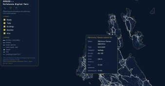
Upon visiting the ARGOS map, users can click on any point of interest – be it a building, a road, a beach, or a general Point of Interest (POI). This interaction triggers a cascade of information, offering contextually relevant data. A standout feature is the calculation of travel times to critical infrastructure, specifically the nearest fire station and ferry port. This functionality is invaluable for emergency response planning and understanding logistical challenges on the island.
Beyond logistical insights, ARGOS v0.0.1 incorporates environmental risk layers. Users can toggle between wildfire risk assessments and flash-flood probability maps. This data visualization is crucial for residents, local authorities, and emergency services, enabling more informed decision-making and preparedness strategies. The project also highlights a serendipitous discovery: a lighthouse, previously uncatalogued or perhaps obscure, is pinpointed with its travel time calculated at 102 minutes, accessible only by boat. This playful yet informative detail underscores the project's ability to unearth and present hidden or overlooked geographical information.
The Technology Stack and Data Sources
The technical foundation of ARGOS is built entirely on open-source components, emphasizing accessibility and cost-effectiveness. The backend is powered by PostGIS, a spatial database extender for PostgreSQL, which handles the complex geographical data. FastAPI, a modern Python web framework, serves the data efficiently. For the frontend map rendering, MapLibre GL is employed, a popular open-source vector tile rendering library, paired with PMTiles for efficient tile delivery. Crucially, the entire project is hosted on GitHub Pages, a free static site hosting service, resulting in a monthly operational cost of effectively €0.
The richness of ARGOS's digital twin is derived from a curated selection of open and attributed data sources. These include:
- OpenStreetMap (OSM): Providing the foundational map data, including roads, buildings, and points of interest.
- Copernicus DEM: The Digital Elevation Model from the European Union's Earth observation program, offering crucial topographical information.
- Sentinel-2: Satellite imagery data from the Copernicus program, likely used for land cover and environmental analysis.
- NASA FIRMS (Fire Information for Resource Management System): Data on active fires, essential for the wildfire risk layer.
- EFFIS (European Forest Fire Information System): Additional data contributing to wildfire risk assessment.
The commitment to using open and attributed data ensures transparency and allows for community contributions and verification. The project explicitly states that all data is attributed, respecting the work of the original providers.
Future Development and Broader Implications
ARGOS v0.0.1 is positioned as a static snapshot, a foundational release. The developer has outlined a clear roadmap for future development, divided into distinct phases. Phase 2 aims to introduce real-time data feeds. This will significantly enhance the dynamic nature of the digital twin, allowing for immediate updates on events such as active fires, weather changes, or traffic conditions. Phase 3 plans to implement a municipality pilot, suggesting a collaboration with local government to test and refine the digital twin's capabilities for practical administrative and emergency management purposes.
The creation of ARGOS is more than just a technical exercise; it's a demonstration of how open data and open-source tools can be combined to create powerful, localized tools. The concept of a digital twin, often discussed in the context of large industrial assets or entire cities, is here applied to a specific island community. This approach offers a scalable model for other regions, particularly those with unique geographical challenges or a high susceptibility to natural disasters. The ability to visualize and analyze complex data in an integrated manner, as ARGOS does, can lead to more resilient communities and better-informed planning. The project implicitly argues that such tools, even when built by a small team or an individual, can provide immense value, challenging the notion that sophisticated digital infrastructure is solely the domain of large corporations or government bodies.
What remains to be seen is how widely this model will be adopted and adapted. Can similar digital twins be rapidly deployed for other islands or remote communities facing similar risks? The success of ARGOS v0.0.1 suggests a strong 'yes,' provided the necessary open data infrastructure and community willingness to collaborate are present. The developer's transparent approach, sharing the stack and data sources, is a crucial enabler for such future replication.